Showing posts with label kent towns and villages. Show all posts

Saturday, March 30, 2013

A Mystery Solved

Some time ago I wrote a post about a mysterious memorial stone I came across in Cockerhurst Road on the outskirts of Shoreham.

 
On one face it is inscribed with a passage taken from the Bible (Hosea) - "Behold therefore I will allure her and will lead her into the wilderness and there I will speak to her heart"....
 
 
On another face the inscription reads "Pray for the soul of E.J.G.B".....
 
 
and on another "and of A.J.B".
 
Thanks to tip offs received from members of Kent History Forum I have managed to get to find out the origins of the stone.

The stone was erected in 1928 by a Miss Maud Berkeley in memory of her late father, Dr E J G Berkeley. She lived at  Little Timberden in the village and ran a Catholic mission chapel.

As well as the stone and a seat, she also erected a 15' high teak crucifix with a life size statue of Jesus.

The crucifix had a somewhat chequered history.

On the 21st January 1943 it was blown down in a gale and on the 27th October 1960 it suffered an even worse fate.

The crucifix was deliberately sawn down and the statue of Jesus vandalised. It would appear that some residents of Shoreham thought the towering crucifix an eyesore.

The crucifix and statue were removed and put into storage for a number of years. Eventually a Miss Cobbold suggested they be relocated to the Carmelite monastery at Quidenham in Norfolk where they remain to this day.

If you have found this post of interest you may also like....

The White Cross of Shoreham

My Darent Valley Walk Part 1

Tin Tabernacles in Kent


Sunday, September 05, 2010

My Darent Valley Walk Part 3 - Otford to Chipstead and Sevenoaks


As regular followers of this blog will be aware, I am walking the Darent Valley Path through Kent in easily digestible segments, as and when time permits.

My latest walk set off from the picturesque village of Otford. I parked my car in a free car park opposite the Bull pub close to the Otford Solar System model I wrote about in My Darent Valley Walk Part 2.
Otford is a good starting point if you are interested in walking in Kent as three long distance routes converge there - the Darent Valley Path, the North Downs Way and the Pilgrims Way.

For the first part of my walk I followed the Pilgrims Way, at this point, actually a busy main road, for a short distance passing the Horns public house and restaurant pictured above. This is a former 15th century coaching inn.


The Darent Valley Path branches off from the Pilgrims Way on the outskirts of the village and passes through a small housing estate before crossing a bridge over the railway line into open fields. At this point the Darent Valley Path branches into two. You have the option of walking to Sevenoaks via Riverhead or to Chipstead via Dunton Green, as I elected to do.


It is a fairly short walk across the fields to Dunton Green where the path eventually emerges by Donnington Manor which now constitutes part of a Best Western Hotel. The manor dates back to the 15th century.


Dunton Green is unfortunately located on the very busy A224 and in order to follow the Darent Valley Path I had to cross over to the other side - easier said than done! Approximately ten minutes later I finally managed to do so and continue on my way.


The path leads across some scrubby heathland and then under the even busier M26 motorway. This section of the walk was spoiled for me by the ever present drone of the traffic in the background.


Moan over. The path continued on through open fields again and intersected the track bed of the long disused Westerham to Dunton Green railway. The line was opened in July 1881 but fell victim to Doctor Beeching's savage rail cuts, closing in 1961.

I found a very interesting web site with lots of pictures of the old railway here.


Eventually I came to Chipstead Lake, the end of this branch of the Darent Valley Path and the first leg of the day's walk. Unfortunately the lake is privately owned and used by the fishing and sailing clubs - members only.

The lake is actually man made. It is a former clay pit. The clay was extracted over many years and used for the local brick and tile industry.


Luckily the small village green overlooks the lake and I sat on a bench, had a bite to eat and consulted my map to work out my route for the rest of the day.

I decided to navigate from Chipstead via Riverhead through to Sevenoaks where I could pick up the other branch of the Darent Valley Path back to Otford. The downside was this would involve quite a lot of walking on tarmac rather than cross country.

On the plus side though my route took me via the centre of historic Chipstead village. Here are some pictures....


These cottages were built in 1694.


The former non conformist chapel parts of which date back to the early 1600's.


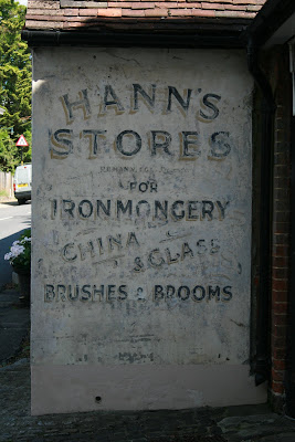
Hann's Store is now an office. It is good to see that the new owners did not paint out the old advertisement as often happens nowadays.


The George and Dragon pub built in the 16th century and still going strong.

My walk continued through Chipstead until I reached Riverhead on the outskirts of Sevenoaks.


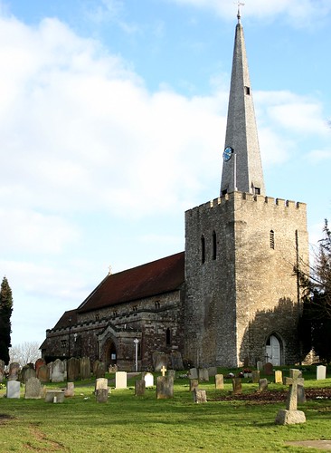
The church of St Mary overlooks a road junction and dominates the town's skyline. The church is modern by Kent standards having been built in 1831 to a Decimus Burton design. As is often the case, I was not able to have a look inside the church as it was all locked up.

I continued along my "favourite" road, the dreaded A224 as far as Sevenoaks railway station where I joined the Darent Valley Path again to head back to Otford. The path, as far as I could see, is not very well marked at this point so it is advisable to have OS Explorer map 147 handy if you wish to follow the route yourself.


The path runs parallel with the railway for a while, through a housing estate, before entering Bradbourne Lakes. The lakes are a hidden gem. I was expecting some scruffy old gravel pits but they are actually small ornamental lakes which once formed part of the 18th century Bradbourne Estate. Over the years the estate was split up and sold off for housing developments. In 1935 the Lakes passed into the ownership of Sevenoaks District Council.


It is an ideal place to take small children. The lakes are full of very tame geese and ducks such as my friend Mr Greylag above. He was angling for a bit of my leftover sandwich but went away empty beaked!

On the other side of the lakes, the Darent Valley Path joins the A25. Once again I spent another age trying to cross this road. A continuous stream of cars and trucks thundering by in both directions.

Safely across the A25 the path skirts along the edge of some more lakes which form part of the Sevenoaks Wildfowl Reserve.

Unfortunately the lakes are fenced off and the trees and undergrowth are so thick it's not possible to see them properly from the path.

Surely a missed trick? In my opinion it would have made this part of the walk more enjoyable if a small clearing could have been made in the trees at some point along the way. You never know, maybe someone from Kent County Council is reading this blog....

Leaving the Wildfowl Reserve the path joins a very quiet country lane (Rye Lane). I followed the lane all the way back into Otford through fields full of sheep and past some of the smartest and colourful static homes I have ever seen before.

UPDATE - for Part 4 of My Darent Valley Walk please see here

If you have enjoyed reading this post, please feel free to leave a comment. They are always welcome.

From the archives...

A Walk Around Grenham Bay

Winter Walks - Nurstead and Camer Park

The White Cross of Shoreham, Kent

Sunday, June 20, 2010

My Darent Valley Walk - Part 1 Farningham to Lullingstone

The tranquil River Darent flows from the hills near Sevenoaks down to the River Thames at Dartford.

I was fortunate enough to have been brought up in this part of Kent and, having done some research on the family tree, it would appear that many of my ancestors were too!

A 19 mile waymarked route called the Darent Valley Path links the towns of Dartford and Sevenoaks and it is my intention to walk the whole route, eventually, as time permits.

To date I have managed to walk two stages. Namely from Horton Kirby through to Farningham and then from Farningham through to Lullingstone. Most people would start from one end or the other but I chose to start in the middle....

In this post I will tell you about the walk I did recently from Farningham to Lullingstone (and back again via a very circuitous route!).

My walk started from the Lion Hotel at Farningham on the banks of the river.

I walked out of Farningham village along the quaintly named Spare Penny Lane. This narrow country lane runs parallel to the river which flows through the valley below. Even on a weekday it was very quiet with only a handful of cars. A nice change from the usual daily hustle and bustle.


On one side of the lane are orchards and fields. On the other, some very nice (and expensive) houses. As you can see, we have very environmentally friendly lawn mowers here in Kent.


A short way along the lane I stumbled across a poignant memorial to New Zealander Flight Lieutenant James Paterson M.B.E. of 92 Squadron R.A.F. who died when his Spitfire X4422 was shot down and crashed nearby on 27th September 1940.

One of Churchill's "few" many thousands of miles from home but not forgotten.

The memorial was erected by the Shoreham Aircraft Museum which I wrote about last year (see The White Cross of Shoreham at the foot of this post). Their aim is to place a memorial for each and every Battle of Britain pilot that lost their life within a ten mile radius of their museum.

Continuing along Spare Penny Lane and approaching the outskirts of the next village, Eynsford, I came across the ruined castle.


Eynsford Castle was built around 1085 shortly after the Norman Conquest. Following a fire in the 1200's it eventually fell into disrepair and was later even used as a kennels for hunting dogs. The castle is now under the care of English Heritage and open to the public (admission free - at time of writing at least).

The waymarked Darent Valley Path directs you away from Eynsford but I would strongly recommend you make a diversion away from the path and take a look at the very picturesque and historic village itself.


The ford across the River Darent from which the village takes it's name. The church of St Martin of Tours was built in the 12th century although, as is often the case in Kent, it may be on the site of an earlier Saxon structure.

Regular readers of this blog will know that I do not usually have much luck with churches. They are almost invariably locked when I try to have a look around. However, on this occasion my luck was in for a change.

A close up of the clock which was inscribed in 1903 with "Grow old along with me, The best is yet to be" taken from Robert Browning's "Rabbi Ben Ezra".

Inside, the church is very plain in comparison to many other churches I have visited in Kent.

Back on the waymarked route the path starts to climb steadily up the side of the valley across open farmland and passing the impressive nine arched red brick Eynsford railway viaduct built in 1859.


There is an unmanned crossing over the railway lines which brings you into a large open field and affords great views along the valley towards Lullingstone.

Unfortunately somewhere around about this point, there was a cock up on the map reading front Reggie! Yes, I know, I know how can anyone get lost on a simple waymarked path?...

Anyway, due to my inadvertent navigational error I somehow ended up continuing up hill and through Lullingstone Golf Course (instead of downhill towards the river). Ah hum.
  
The upside of this error was that I had to walk through some woodland which was absolutely carpeted with bluebells. Eventually I got back on track and found my way down the bottom of the valley to the Lullingstone Visitor Centre.

This Centre is run by Kent County Council and contains a (very expensive) cafe, toilets and a small book/gift shop. There is a pay and display car park which is very busy at weekends. (Picture by Indigoprime)

I treated myself to an extortionately priced Bakewell tart and cup of tea before setting off again along the river bank back towards Eynsford. The path leads past the Tudor gate house to Lullingstone Castle, ancestral home of the Hart-Dykes.
Continuing on I came to the site of the Lullingstone Roman Villa which is open to the public.

The remains of the villa, which were discovered accidentally by workmen digging post holes during the mid 18th century, include several very well preserved mosaic floors. Well worth a visit.
  
I took another country lane passing under the towering Eynsford viaduct that I'd seen from above earlier in the day and headed back into the village.

Rather than follow the Darent Valley Path back to Farningham once more, I decided to take another footpath out of Eynsford, up the side of the valley, across open farmland towards the hamlet of Maplescombe.
It was quite an uphill hike but the view was well worth the effort. After a mile or so across country, the footpath joined Maplescombe Lane and I followed this back to the Lion Hotel at Farningham just in the nick of time as the Heavens decided to open!

UPDATE - for Part 2 of My Darent Valley Walk please see here

If you have any comments about this post, please feel free to let me know. They are always welcome.

If you have enjoyed this post, you may also like -


Wednesday, May 26, 2010

Visit to West Malling

Not surprisingly, this is a follow on to my post "A visit to East Malling" which I wrote a few weeks ago.

More specifically this post is about the village church of St Marys which, I think, is rather special, particularly if you are also interested in history like me.

From the outside,the church is not unpleasing to the eye .....

St Mary church, West Malling, Kent

However, on the inside, it's even better ....

Stained Glass Window - St Mary, West Malling, Kent

The stained glass windows are fantastic. Some of the best I have ever seen.

The church was originally built shortly after the Norman Conquest of England by Bishop Gundulf who was also responsible for the construction of Rochester Cathedral and castle.

Over the centuries many changes and additions were made including the construction of the spire in the 1700's. (The same spire was depicted on the back of ten pound notes during the 1990's)

One of the most interesting things to be seen inside the church is the ornate tomb of Sir Robert Brett who died in 1620. He had the grand titles of Gentleman Usher of the Privy Chamber and King's Sergeant and is buried alongside wife and son.

Tomb at St Mary, West Malling, Kent

Tomb at St Mary, West Malling, Kent

More macabre details on the tomb...

Bat and Skull on Tomb at St Mary, West Malling, Kent

Skeleton on Tomb at St Mary church, West Malling, Kent

One of the monuments was a stark reminder of how tragically high infant mortality rates were a couple of centuries ago.....

Memorial Tablet at St Mary, West Malling, Kent

Benjamin Hubble and his wife Ann outlived eight of their ten children.

Plaque at St Mary church, West Malling, Kent

A quote taken from the Bible (Peter). I believe the plaque was made during the reign of King James II (1685 - 1688) the last Catholic King of England who was ousted in the Glorious Revolution.

These are just a few of the interesting things to be found inside the church. My wife and I must have spent at least an hour or so looking around.

Grave of Squadron Leader A E Hall

The graveyard outside contains many reminders of the town's long association with Royal Air Force.

During the Battle of Britain, despite being heavily bombed the airfield was able to remain operational. Guy Gibson VC, later to become leader of the famous Dambuster raid, was stationed at RAF West Malling during 1941. In 1944, Spitfire aircraft were used to intercept and destroy V1 rockets (doodlebugs) before they could reach London.

After the RAF left in 1969, the airfield remained in civilian hands until around 1992 when it finally closed and was redeveloped into the new "village" of Kings Hill.

Squadron Leader Hall of 25 Squadron is buried next to his colleague and co-pilot Flying Officer Levett.

Grave of Flying Officer A G Levett

Squadron Leader Hall and Flying Officer Levett were both sadly killed on 4th February 1957 when their Gloster Meteor NF14 night fighter WS 753 flew into high ground four miles east of Oxford during a night navigation exercise.

If you have enjoyed reading this post, please leave a comment. They are always welcome.

You may also like...

Manston Airport and the Hurricane and Spitfire Memorial

They Burned for Their Beliefs

Tracing the Family Tree in Chelsfield, Kent

Tuesday, May 18, 2010

Demolition of Blue Circle / Lafarge Cement Works Northfleet (part 2)

Following on from my blog post about the demise of the Blue Circle / Lafarge Cement works at Northfleet, a series of pictures taken for me by a friend showing the last moments of the iconic 550' chimneys on 28th March 2010.....

12-04-2010 045

12-04-2010 047

12-04-2010 049

12-04-2010 051

12-04-2010 052

12-04-2010 054

12-04-2010 056

12-04-2010 057

If you have enjoyed this post, you are more than welcome to leave a comment. You may also enjoy the following posts too...

W T Henley / AEI Cable Works

Porcupines and Masons

Viscount Northcliffe - Pioneer Press Baron