This post follows on from my last which covered the final leg of my Darent Valley Walk from Dartford town centre through to the mouth of Dartford Creek.
I came across these old photographs of Dartford Creek which I guess were probably taken in the early 1950's or possibly a bit earlier.
 Above is an aerial shot of the Burroughs Wellcome & Co pharmaceutical factory in the foreground and London Paper Mills in the background.
Burroughs Wellcome & Co through various mergers and acquisitions finally evolved into Glaxo Smith Kline and was once one of the biggest (if not the biggest) employers in Dartford.
Burroughs Wellcome & Co was founded in 1880 by two London based American pharmacists, Silas Burroughs and Henry Wellcome. In 1889 they purchased the site of the Phoenix paper mill in Dartford and set up their own factory which went from strength to strength with up to 1300 employed at it's peak.
 Raw materials for the factory were transported up the Creek by barge and the company had it's own wharf.
Over the years many important drugs including insulin for the treatment of diabetes, Zovirax for the treatment of herpes and Retrovir used by HIV/AIDS sufferers around the world were developed.
Unfortunately pharmaceutical manufacturing in Dartford ceased a few years ago and the factory site has now been demolished and is awaiting redevelopment.
 London Paper Mills operated from Riverside Mill. The company was formed in 1889 and initially produced 250 tons of paper per week. In 1909 the company was taken over by Albert Reed and production increased to 400 tons per week. The company mainly specialised in the manufacture of printing paper. The mill remained open until 1968.
 In the picture above barges are seen on the Creek loaded with wood pulp and esparto grass. The esparto grass came from the Mediterranean by ship to the London Docks and was then put into barges and towed up to Dartford Creek.
 The esparto grass was then transported by lorry to the Horton Kirby Paper Mills (mentioned in My Darent Valley Walk Part 4). It was used to manufacture fine quality writing paper.
Further down the Creek, the Ettrick Forest Mill was established in 1862. In 1868 this was taken over by the Daily Telegraph and known as Dartford Paper Mills. Newsprint was produced for the Fleet Street presses and in it's heyday 700 staff were employed.
The mill later passed into the ownership of Wiggins Teape and paper production continued on the site until 2009 when it was closed and demolished. The site is currently waiting redevelopment (a familiar theme).
 The Greaseproof Paper Mill seen above was established in 1933. At this time greaseproof paper was used extensively to wrap foodstuffs such as cheese or meat which were weighed and sold loose in small local shops.
 The Greaseproof Paper Mill seen above was established in 1933. At this time greaseproof paper was used extensively to wrap foodstuffs such as cheese or meat which were weighed and sold loose in small local shops.
 The mill only had a short life operating until 1957. Demand for greaseproof paper presumably plummeted with the establishment of supermarkets in the 50's and the introduction of packaged foods.


J & E Hall Ltd was another major employer in Dartford. They were involved in engineering but I will write more about them in another future post when time permits.
In the late 1970's ships were broken up in Dartford Creek below the lock. One of these ships was the Royal Navy Type 41 frigate HMS Leopard. She was built in Portsmouth in 1955.
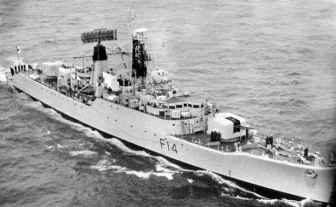
In October 1977 she was sold for scrap. At 100 metres in length she was too long to navigate Dartford Creek. To get around the problem the breakers towed the Leopard from the Naval Dockyard at Chatham to Beckton on the Thames were the stern section was removed.
The remaining forward three quarters of the ship could then be towed down to Dartford Creek for demolition.
The Leopard was the largest ship to be scrapped at Dartford. The breakers mainly disposed of trawlers and Thames barges. The business later transferred from Dartford Creek to Gravesend - probably a good thing for the water in the Creek.
If you have enjoyed this post you may also like...


